![](/images/other/stat-length.png)
![Trail On foot Les Belleville - col de Pierre Blanche - Photo](https://media.geolcdn.com/t/1900/400/ext.pjpeg?maxdim=2&url=https%3A%2F%2Fstatic1.geolcdn.com%2Fsiteimages%2Fupload%2Ffiles%2F1545311037marcheuse_200dpi.jpg)
col de Pierre Blanche
franquen
User
![Length](/images/other/stat-length.png)
Length
13.9 km
![Max alt](https://static1.geolcdn.com/siteimages/upload/files/1508320355ic_sort_altitude_max_24dp.png)
Max alt
2630 m
![Uphill gradient](https://static1.geolcdn.com/siteimages/upload/files/1508320355ic_sort_den_pos_24dp.png)
Uphill gradient
817 m
![Km-Effort](/images/other/stat-length.png)
Km-Effort
25 km
![Min alt](https://static1.geolcdn.com/siteimages/upload/files/1508320355ic_sort_altitude_min_24dp.png)
Min alt
1859 m
![Downhill gradient](https://static1.geolcdn.com/siteimages/upload/files/1508320355ic_sort_den_neg_24dp.png)
Downhill gradient
815 m
![Boucle](https://static1.geolcdn.com/siteimages/upload/files/16400158638029165_repeat_loop_refresh_sync_direction_icon.png)
Boucle
Yes
Creation date :
2020-08-19 07:06:38.347
Updated on :
2020-08-19 14:59:11.458
![On foot](https://static1.geolcdn.com/sitytour/trail-icons/100.png)
--
Difficulty : Medium
![Scan this QR Code to open this trail in the SityTrail application](https://capi.geolives.com/qq0zvz2zws4bq2lad0pu/sitytour/trails/2520030/qr.png?size=200)
FREE GPS app for hiking
About
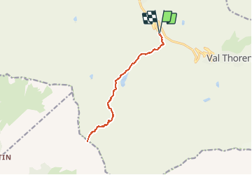
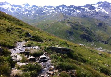
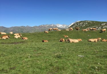
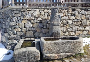
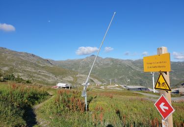
Trail On foot of 13.9 km to be discovered at Auvergne-Rhône-Alpes, Savoy, Les Belleville. This trail is proposed by franquen.
Description
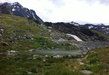
démarrage de la Chasse au dessus des Ménuires, passage au lac du Lou puis au lac des Pierres Blanches (avec un bon bain frais au retour).
Positioning
Country:
France
Region :
Auvergne-Rhône-Alpes
Department/Province :
Savoy
Municipality :
Les Belleville
Location:
Saint-Martin-de-Belleville
Start:(Dec)
Start:(UTM)
307661 ; 5019897 (32T) N.
Comments
Trails nearby
![Trail Walking Les Belleville - FR - VAL THORENS - Circuit des lacs de Val-Thorens - Photo](https://media.geolcdn.com/t/375/260/ext.jpg?maxdim=2&url=https%3A%2F%2Fservices.sitytrail.com%2FGeolivesWS%2FDownloadMedia.ashx%3FTrailID%3D333495%26Media%3D20140811122637.jpg)
![Walking Walking](https://static1.geolcdn.com/sitytour/trail-icons/101.png)
FR - VAL THORENS - Circuit des lacs de Val-Thorens
Walking
Very easy
(1)
Les Belleville,
Auvergne-Rhône-Alpes,
Savoy,
France
![](/images/other/stat-length.png)
6.2 km | 8.6 km-effort
4h 15min
![](https://static1.geolcdn.com/siteimages/upload/files/16400158638029165_repeat_loop_refresh_sync_direction_icon.png)
Yes
![Trail Walking Les Belleville - FR - VAL THORENS - Lac du Montaulever - Photo](https://media.geolcdn.com/t/375/260/ext.jpg?maxdim=2&url=https%3A%2F%2Fservices.sitytrail.com%2FGeolivesWS%2FDownloadMedia.ashx%3FTrailID%3D332855%26Media%3D20140810110245.jpg)
![Walking Walking](https://static1.geolcdn.com/sitytour/trail-icons/101.png)
FR - VAL THORENS - Lac du Montaulever
Walking
Very easy
(2)
Les Belleville,
Auvergne-Rhône-Alpes,
Savoy,
France
![](/images/other/stat-length.png)
4.5 km | 8.3 km-effort
2h 9min
![](https://static1.geolcdn.com/siteimages/upload/files/16400158638029165_repeat_loop_refresh_sync_direction_icon.png)
Yes
![Trail Walking Les Belleville - le lou-la masse-les lacs - Photo](https://media.geolcdn.com/t/375/260/ext.jpg?maxdim=2&url=https%3A%2F%2Fservices.sitytrail.com%2FGeolivesWS%2FDownloadMedia.ashx%3FTrailID%3D601214%26Media%3D20160720162358.jpg)
![Walking Walking](https://static1.geolcdn.com/sitytour/trail-icons/101.png)
le lou-la masse-les lacs
Walking
Very difficult
(1)
Les Belleville,
Auvergne-Rhône-Alpes,
Savoy,
France
![](/images/other/stat-length.png)
23 km | 43 km-effort
7h 2min
![](https://static1.geolcdn.com/siteimages/upload/files/16400158638029165_repeat_loop_refresh_sync_direction_icon.png)
No
![Trail Walking Les Belleville - Le sentier des Choumes ( N °9) - Photo](https://media.geolcdn.com/t/375/260/5cb3a0b1-6ffc-4a97-954a-79c4931bc02f.jpg&format=jpg&maxdim=2)
![Walking Walking](https://static1.geolcdn.com/sitytour/trail-icons/101.png)
Le sentier des Choumes ( N °9)
Walking
Easy
Les Belleville,
Auvergne-Rhône-Alpes,
Savoy,
France
![](/images/other/stat-length.png)
6.7 km | 8.8 km-effort
1h 36min
![](https://static1.geolcdn.com/siteimages/upload/files/16400158638029165_repeat_loop_refresh_sync_direction_icon.png)
No
![Trail Walking Les Belleville - N°1 - La découverte des village au fil du Doron - Photo](https://media.geolcdn.com/t/375/260/15306859-1875-4a25-b739-668d92dd6d6e.jpg&format=jpg&maxdim=2)
![Walking Walking](https://static1.geolcdn.com/sitytour/trail-icons/101.png)
N°1 - La découverte des village au fil du Doron
Walking
Easy
Les Belleville,
Auvergne-Rhône-Alpes,
Savoy,
France
![](/images/other/stat-length.png)
9.4 km | 12.4 km-effort
1h 54min
![](https://static1.geolcdn.com/siteimages/upload/files/16400158638029165_repeat_loop_refresh_sync_direction_icon.png)
No
![Trail Walking Les Belleville - Le sentier Giraud - N° 8 - Photo](https://media.geolcdn.com/t/375/260/f9a4a370-f6ae-440a-97ef-2e1286f7b148.jpg&format=jpg&maxdim=2)
![Walking Walking](https://static1.geolcdn.com/sitytour/trail-icons/101.png)
Le sentier Giraud - N° 8
Walking
Easy
Les Belleville,
Auvergne-Rhône-Alpes,
Savoy,
France
![](/images/other/stat-length.png)
5 km | 6.5 km-effort
1h 9min
![](https://static1.geolcdn.com/siteimages/upload/files/16400158638029165_repeat_loop_refresh_sync_direction_icon.png)
No
![Trail Walking Les Belleville - La Croisette - Le Plan d'eau des Bruyères - Photo](https://media.geolcdn.com/t/375/260/debed00d-5703-4a8c-a041-854ec81465b6.jpg&format=jpg&maxdim=2)
![Walking Walking](https://static1.geolcdn.com/sitytour/trail-icons/101.png)
La Croisette - Le Plan d'eau des Bruyères
Walking
Easy
Les Belleville,
Auvergne-Rhône-Alpes,
Savoy,
France
![](/images/other/stat-length.png)
7.7 km | 10.5 km-effort
1h 53min
![](https://static1.geolcdn.com/siteimages/upload/files/16400158638029165_repeat_loop_refresh_sync_direction_icon.png)
Yes
![Trail Walking Les Belleville - Lac du Lou - Photo](https://media.geolcdn.com/t/375/260/2753a11b-3e3e-4ec9-8c50-abd7984db138.jpg&format=jpg&maxdim=2)
![Walking Walking](https://static1.geolcdn.com/sitytour/trail-icons/101.png)
Lac du Lou
Walking
Medium
Les Belleville,
Auvergne-Rhône-Alpes,
Savoy,
France
![](/images/other/stat-length.png)
11.3 km | 15.5 km-effort
4h 38min
![](https://static1.geolcdn.com/siteimages/upload/files/16400158638029165_repeat_loop_refresh_sync_direction_icon.png)
Yes
![Trail Walking Les Belleville - descente point de la masse - Photo](https://media.geolcdn.com/t/375/260/ext.jpg?maxdim=2&url=https%3A%2F%2Fstatic1.geolcdn.com%2Fsiteimages%2Fupload%2Ffiles%2F1553511878bg_sport_marche.png)
![Walking Walking](https://static1.geolcdn.com/sitytour/trail-icons/101.png)
descente point de la masse
Walking
Medium
(1)
Les Belleville,
Auvergne-Rhône-Alpes,
Savoy,
France
![](/images/other/stat-length.png)
9.3 km | 13.3 km-effort
3h 30min
![](https://static1.geolcdn.com/siteimages/upload/files/16400158638029165_repeat_loop_refresh_sync_direction_icon.png)
No